The Restoration Skip to main content
An Atlas of Latter-day Saint History

The Restoration

Section 1, 1820-1845

The Restoration of the Church of Jesus Christ through the Prophet Joseph Smith created a geographic imprint upon which we can still trace the people, places, and events that were fundamental to the Church. The migration of Joseph’s ancestors first led them to New England and later to upstate New York, as the Erie Canal provided access to better lands to the west. The differing Protestant religious backgrounds of the newly arriving migrants created a social milieu that influenced the spiritual development of Joseph, while the unique geography of the upstate New York area, created by glaciation south of the Great Lakes, contained places that figured centrally in the sacred experiences of the boy prophet.

Following the organization of the Church in 1830, Joseph and new members and officers joined the westward movement of Americans to the Ohio, Mississippi, and Missouri river valleys, where they colonized the fertile land, founded communities, and ultimately came into conflict with other settlers of the region. In less than 15 years the Prophet Joseph and early missionaries crisscrossed the Mississippi–Ohio valley and traveled to the East Coast and Europe in their missionary journeys and in ministering to the congregations of the new faith. The geography they created included numerous farms, towns, two temples, and even the large city of Nauvoo. Within this new geography, sacred events occurred that resonate through the Church of Jesus Christ even today, including the revelation and translation of scriptures that are part of the standard works Church members revere as holy.

1830s Ohio and the Western Reserve
The Connecticut Western Reserve got its name when the states were relinquishing their western land claims to the new federal government in 1786; Connecticut retained this small part of its claim until 1800.

Although the Western Reserve was surveyed and available for settlement after the Connecticut Land Company purchased the land in 1795, growth was slow until the Erie Canal made the shoreline area more accessible. Meanwhile, the southern portion of the state was growing rapidly, aided by the Ohio River and the National Road.

In 1830, the area designated as the Connecticut Western Reserve was a lightly populated but rapidly growing frontier; early resident Eliza R. Snow described it as being “the jumping off place.”
Brandon Plewe, Karl Ricks Anderson
Bainbridge, Colesville, and Harmony
Near the village of South Bainbridge (now Afton) was the home of Josiah Stowell, a well-to-do farmer who hired Joseph Smith and his father to look for a rumored Spanish silver mine in Harmony. Although the search was unproductive, Joseph continued to work at the Stowell farm during 1826 while he courted Emma Hale. The two were married in South Bainbridge in January 1827.
Colesville Township contained the farm of Joseph Knight Sr., who also employed Joseph Smith Jr. in 1826. Knight and his family were quickly converted to Joseph’s teachings, often supporting him during the translation as well. Many of their friends also believed, but enough people opposed Joseph that he was taken to court (and acquitted) here at least twice. In June 1829, the Melchizedek Priesthood was restored somewhere between here and Harmony. In 1830, one of the first branches of the newly organized Church of Christ was created at the Knight farm.
Harmony Township (now Oakland) was first visited by Joseph Smith Jr. when he boarded at the home of Isaac Hale while employed by Josiah Stowell to search for a silver mine in early November 1825. Rather than precious metal, Joseph discovered Hale’s daughter Emma. Hale never believed Joseph’s stories of his visions and opposed their marriage, but he eventually sold Joseph and Emma a portion of his farm along the Susquehanna River. This was their primary residence for most of 1828–30, and here Joseph (with Emma, Martin Harris, and Oliver Cowdery) translated most of the Book of Mormon and received the Aaronic Priesthood in 1829. Joseph and Emma were still residing here in 1830, when Joseph began retranslating the Bible. Larry C. Porter
Brandon Plewe, Mapping Mormonism p.21
Birthplaces of Early Church Leaders
Included here are members of the First Presidency, Quorum of Twelve Apostles, First Seven Presidents of the Seventy, Stake Presidencies, Three Witnesses, Presiding Bishops, and Patriarchs (Seventies were not General Authorities until 1976). There is an obvious predominance of leaders from New England and upstate New York; this led to a definite New England culture in the early Church. Of the leaders shown here whose previous religious affiliations are known, fourteen had associated with Methodism, eight with Congregationalism, seven with Alexander Campbell’s “restoration” movement (eventually called the “Disciples of Christ”), six with the Baptists, three with Presbyterianism, three with Unitarianism or Universalism, and one each for Anglicanism, Quakerism, Shakerism, and Lutheranism. Some leaders had multiple religious affiliations before joining with the Latter-day Saints; others had none. J. Spencer Fluhman
Brandon Plewe, Mapping Mormonism p.13
Branches in the United States, 1831-1844
During the lifetime of Joseph Smith, missionaries spread throughout the United States and British Canada. As they found converts, they organized them into branches—small congregations (often as small as 6–7 members) with a presiding priesthood holder, preferably an elder, but often an adult teacher or priest. The distribution of branches found during this period reflects several different types of missionary labor: “Friends and family” missionaries established many of the early branches in their hometowns in New England and New York. “Wandering” missionaries preached as they traveled through the countryside, forming corridors of rural branches along major travel routes. “Circuit Rider” missionaries traveled within a region, forming clusters of branches. Urban missionaries used rented halls and advertising to establish a presence in major cities.
Fewer missionaries served in the South, probably due to cultural differences as well as distance, so branches there were limited to isolated pockets built up by dedicated long-term missionaries such as Jedediah M. Grant and Wilford Woodruff.
According to the 1830 organizational revelation of the Church (D&C 20), the priesthood holders in each region (missionaries and local members) were to hold quarterly conferences to strengthen each other and conduct business. These were not held regularly until 1834, but after they were promoted and implemented by the newly called Apostles in 1835, regular conferences were reported in many regions, especially in western New York and Michigan. These conferences also served as regional administrative units (the same way the term was used in the Methodist Church), eventually being renamed districts as used in missions today. David J. Whittaker
Mapping Mormonism p.41
Caldwell and Daviess Counties, 1839
From 1836 until early 1839, Caldwell County became the main settlement location for Mormons gathering to northern Missouri. Land parcels could be purchased from the government land office at nearby Lexington, generally for $1.25 per acre. Although Far West became the main place of Mormon gathering, smaller settlements were established on or near the creeks, typically bearing the name of the original inhabitants. These outlying settlements were generally scattered clusters of farms, not platted villages.

A few Mormons began settling Daviess County in 1837, but most came in 1838. Land transactions in Daviess were different than in Caldwell; because it was not yet open to government sale, settlers filed a preemptive claim for up to 160 acres. The tenant could then live on the property and make improvements with the expectation that when the federal government officially offered the land for sale, he would have the first rights to buy the land. Adam-ondi-Ahman (Diahman for short) soon became the largest settlement in the county (platted as a city much like Far West), but other Mormon settlements also arose, soon coming into conflict with the non-Mormon settlers, who were building towns such as Gallatin and Millport. Unlike Kirtland and Nauvoo, when the Mormons abandoned their settlements in 1839, they were not reinhabited by other settlers but became ghost towns, eventually reverting to farmland.
Brandon Plewe, Alexander L. Baugh
Church Branches in the U.S. and Canada, 1831-1839
This map shows at least 270 branches known to exist between 1831 and 1839, but these never existed all at once. The average life of a branch was only about two or three years, as members soon emigrated to Kirtland or Missouri, or were forgotten after the missionaries left.

During this time, the Saints built a temple in Kirtland; three were planned in Missouri, but each time they were driven out before construction could even begin.
Brandon Plewe
Church Growth in the "Burned-Over District"
Methodists, Presbyterians, and Baptists squared off in upstate New York before 1840. Joseph Smith’s many autobiographical references to these groups and to their individual members as his leading antagonists bear out the fact that these groups dominated the region. They could unite against Joseph Smith’s fledgling Church, but just as often they disagreed among themselves. Theologically, they disagreed about predestination and free will. Ecclesiastically, they differed over questions of church government. Methodists and Presbyterians argued bitterly with Baptists over the question of infant baptism.
Brandon Plewe, J. Spencer Fluhman
Church Organization in the Kirtland-Missouri Era
During the 1830s, ecclesiastical quorums, councils, and offices were established to administer the spiritual and temporal affairs of the Church. At the organization of the Church in 1830, leadership was simple: Joseph Smith and Oliver Cowdery presided over the Church as first and second elders. Over the next several years, the numerical and geographical growth of the Church necessitated a more complex leadership structure.
Brandon Plewe, Mapping Mormonism p.39
Church Organization in the Nauvoo Era
During the Nauvoo era, Joseph Smith made many significant changes to the organization of the Church. Some of these changes resulted from apostasies in Ohio and Missouri. In the First Presidency, Hyrum Smith was added as Assistant President (and presumptive heir) and Patriarch in 1841. Also, in Nauvoo the Quorum of the Twelve played a much greater role in governing the Church than it had previously, due to their success in England and in orchestrating the exodus from Missouri. Seventies quorums proliferated, with dozens by 1844. Several stakes were organized, Nauvoo being by far the most important, with a presidency, high council, and, by 1843, 13 bishops (who were still not ecclesiastical leaders over separate congregations but administrators of temporal affairs). Most of the new stakes in this period were not regional groups of congregations as they are today but were merely large branches (200–300 or more members) that had leadership in addition to the traditional presiding elder, such as a high council and a bishop. It is even unclear how much jurisdiction the Nauvoo Stake had over surrounding settlements. Only the Iowa Stake (also known as the Zarahemla Stake) has a clear record of jurisdiction over multiple branches. This vague structure evolved gradually until the modern hierarchy of stakes, wards, and branches was standardized in 1877.
Brandon Plewe, Mapping Mormonism p.58
Cities in the West Based on the City of Zion Plat
Commerce town plat, 1834
Brandon Plewe, Donald Q. Cannon
Divergent Paths of the Restoration
Evacuating Missouri, 1838
After the extermination order was issued, the Saints were forced to leave Missouri whichever direction they could. Fear of Indian attacks in the West probably kept the move directed eastward. Some families strayed into Iowa, but most made the 200-mile journey northeast toward Quincy, Illinois, the closest major town across the state line, tending to follow established roads. From personal accounts of the trek, a northern route extending eastward from Far West through Chillicothe and Shelbyville to Quincy, and a southern route connecting Far West with Tinney’s Grove, Keytesville, Huntsville, and Quincy, appear to have been the prevalent routes. Sean Cannon
Mapping Mormonism p.51
Exodus from Missouri, 1838-1839
After the extermination order was issued, the Saints were forced to leave Missouri whichever direction they could. Fear of Indian attacks in the West probably kept the move directed eastward. Some families strayed into Iowa, but most made the 200-mile journey northeast toward Quincy, Illinois, the closest major town across the state line, tending to follow established roads. From personal accounts of the trek, a northern route extending eastward from Far West through Chillicothe and Shelbyville to Quincy, and a southern route connecting Far West with Tinney’s Grove, Keytesville, Huntsville, and Quincy, appear to have been the prevalent routes.
Brandon Plewe, Sean Cannon
Far West, Missouri
Located in Mirabile Township in Caldwell County, Far West was the largest Mormon settlement in northern Missouri. Although its existence was relatively short-lived (1836–39), it became the center of the religious, political, and social activities of the Latter-day Saints living in the region. Originally, Far West was to have been one square mile according to the City of Zion plan but was soon expanded to two miles square (four times its original size). Joseph Smith took up permanent residence in the community on March 14, 1838, making it the new headquarters of the Church. On July 4, during a festive celebration, a site was dedicated for a temple on the town’s public square.

By the early summer of 1838, Far West was a thriving community consisting of 150 homes, several stores, blacksmith shops, a printing establishment, a school, and two hotels. Throughout the summer and early fall, the community continued to increase in number and size as companies of Mormon immigrants arrived from the East. As hostilities increased in the fall, large numbers of Mormons from outlying areas, particularly Daviess County, took up temporary residence in or near Far West before leaving the state beginning in early 1839.

Far West disappeared almost as quickly as it had appeared. Dissident John Whitmer, who had originally purchased most of the town site, turned the former town into a farm. On this aerial photograph, it is clear that the former town is now cropland; nothing more than a few foundations have been found.
Brandon Plewe, Alexander L. Baugh
Greater Nauvoo Area
The majority of Mormon settlement occurred near Nauvoo in Hancock County, Illinois, and Lee County, Iowa. The Mormons bought large tracts of land on both sides of the Mississippi River in these two counties. Further afield, refugees from Missouri and gathering converts settled in scattered places throughout western Illinois, either on their own or among other residents, forming dozens of new branches. Some of these branches were even organized as stakes. These "stake-branches" were not regional organizations in the modern sense of the term, but single large branches with a presidency, a bishop, and a high council. There were also branches just beyond the limits of this map, but they tended to be made up of local converts rather than Mormons gathering from elsewhere.
Brandon Plewe
Independence Missouri in 1833
A view of Independence at the height of Mormon settlement, looking toward the southwest. The white outline shows the original plat of the town of Independence, while yellow outlines show LDS purchases in town and to the west. Independence was established in 1827, two years after the Osage Tribe ceded Missouri’s western strip to the state. The old Osage Trace became the route to Santa Fe, passing west through the upper edge of the county and through Independence, where it branched. The western link, called the Westport Road, extended to the Native American lands to the west and also gave the Mormons access to their settlements in Kaw Township. Independence, which Washington Irving observed to be a “little straggling frontier village” in 1832, was primarily peopled by hearty frontier men from the southern states. These settlers cleared their timbered lots, planted corn fields, built rustic houses, and opened businesses. The two nearby river landings (Independence Landing two miles north and Blue Mills Landing six miles northeast) brought to the village adventurers, Indian traders, trappers, explorers, and those who had reason to break loose from the constraints of civilization. Max H. Parkin
Brandon Plewe, Mapping Mormonism, p.33
International Missions, 1832-1844
Missionaries first gained converts in Upper Canada (the future Ontario) in 1832, and their success among recent British immigrants led to the opening of Britain (see p. 46), which would be the most successful mission in the Church for decades. Following divine injunctions, Joseph Smith wanted missionaries to visit all the nations and islands of the sea to teach the gospel, and although most of the earliest foreign missions were short-lived, they reveal a serious commitment to take the gospel message to all nations. Some calls were opportunistic: English members who were traveling to Germany, India, and Australia for various reasons were called to preach the gospel while they were there. Other missionaries were called to places well beyond what was easy to accomplish; most were not fulfilled.

One of the most successful missions was to the Society Islands (Tahiti). In the spring of 1843, Addison Pratt, Benjamin F. Grouard, Noah Rogers, and Knowlton F. Hanks (who died at sea) were called by Joseph Smith to travel to the South Pacific to teach the gospel. Originally intending to go to the Sandwich Islands (Hawaii), they instead stayed in French Polynesia, serving the first foreign-language mission in the Church. They arrived on April 30, 1844, on Tubuai Island, where Pratt stayed. Rogers and Grouard sailed to Tahiti, arriving on May 14, 1844. Rogers returned to America in 1845, but Pratt and Grouard remained for several years longer, baptizing about 2,000 Polynesians. By the time Pratt had returned to the United States, he had circumnavigated the globe, probably the first Mormon to do so.
Brandon Plewe, Mapping Mormonism p.42
Jackson and Clay Counties, Missouri
While most of the population of Jackson and Clay counties lived on scattered homesteads in the woodland fringe, Latter-day Saints established dense communities (five in Jackson County 1831–33, several more in Clay County 1834–36).
Brandon Plewe, Mapping Mormonism p.35
Joseph Smith's Ancestry
The migrations of the Smith and Mack families reflect some of the main themes of New England history before 1830. Solomon Mack, Joseph Smith’s maternal grandfather, came of age in Lyme, Connecticut, and spent his teenage years in hard agricultural labor. A veteran of the French and Indian and Revolutionary wars, Mack married Lydia Gates in 1759 and spent most of his adult life in various money-making ventures. After a long series of adventures and disappointments, Mack experienced a Christian conversion late in life. Lydia, who had joined a Congregational church in adulthood, had been the primary religious influence in the lives of the children. The Macks’ youngest child, Lucy, met Joseph Smith, son of Asael and Mary Duty Smith, on a visit to a brother in Tunbridge, Vermont. The Smiths had lived in Topsfield, Massachusetts, for four generations; but Asael, the youngest of five children and lacking an inheritance in land, left the village in search of a living in early adulthood. After several attempts at farming in eastern Massachusetts and New Hampshire, the Smiths settled in Vermont in 1791. Asael and some of his family, including Joseph Smith Sr., were drawn to Universalism, a liberal Christian movement that emphasized God’s reasonableness and the “universal” salvation of the human family. The Joseph and Lucy Smith family also moved several times in search of economic stability (see p. 14) and, like their ancestors, found themselves caught between the Calvinist orthodoxy of New England’s traditionally dominant churches and the heterodox doctrines of Universalism. J. Spencer Fluhman
Brandon Plewe, Mapping Mormonism p.12
Joseph Smith's Travels in the Kirtland Area
While living in northeastern Ohio, Joseph traveled extensively in the area surrounding Kirtland. He held Church conferences in Hiram, Orange, Amherst, Norton, and New Portage. Joseph visited family members in Chardon, Fairport, and Painesville. He preached the gospel as a missionary in Shalersville, Ravenna, and Huntsburg.
Brandon Plewe, Donald Q. Cannon
Joseph Smith's travels in the Nauvoo Area
Most of Joseph Smith’s travels during the Nauvoo Era (1839–44) were in eastern Iowa and western Illinois, fairly close to Nauvoo. He visited family in Green Plains, Plymouth, and Macomb. Joseph held Church meetings in Quincy, Ramus, and Yelrome. He visited Quincy, Keokuk, Fort Madison, and Burlington while cruising on the Maid of Iowa on the Mississippi River.
Brandon Plewe, Donald Q. Cannon
Joseph Smith's Travels in Western New York
Western New York was a rapidly developing frontier between 1820 and 1830, as the woodland was cleared for farms and new towns sprang up. Toll turnpikes and the Erie Canal (completed in 1825) connected the towns. Although his exact route is not always known, Joseph Smith traveled the 100 miles connecting west-central and south-central New York through Ithaca more than 20 times, either by foot or by wagon (the latter often borrowed from friends). Larry C. Porter
Brandon Plewe, Mapping Mormonism, p.21
Kirtland in 1837
Initially, the focus of the village was in “the flats” south of the Chagrin River. At this time, the Newel K. Whitney store at the crossroads was essentially the headquarters of the Church: Joseph Smith had an office there, and the School of the Prophets—a training program for priesthood leaders and missionaries—was held upstairs.
By 1835, a new city was emerging on “the Bluffs” to the south, centered on the temple and following the planned grid pattern of the City of Zion. However, only a few of the 225 planned blocks (covering an area twice the size of this map) were developed before disaffected Church leaders drove Joseph out of Kirtland, along with most of the members of the Church loyal to him.
It should be noted that this reconstruction is not entirely certain. Some features have survived to the present (including the temple and the Whitney store); many locations are known from extensive historical and archaeological evidence, but some homes shown here are only conjectures based on general statements of the geography of Kirtland. Mark L. Staker
Brandon Plewe, Mapping Mormonism p.31
Locations of Revelations in the Doctrine and Covenants
The history of the Doctrine and Covenants mirrors the early history of the Church. The earliest revelations, through 1830, are from the Church’s New York–Pennsylvania period. When Joseph Smith and his followers moved to northeast Ohio in 1831, that area became the focal point of the Prophet’s revelatory work. Half of the sections in the Doctrine and Covenants were received during Joseph’s seven-year stay there, evidence of the rapid development of Church doctrine and practice during that period. Meanwhile, Latter-day Saints began to colonize western Missouri, so during the 1830s, revelations were divided between the two gathering places. Revelations received in western Illinois in the first half of the 1840s reflect the Church’s establishment of a new gathering place there, from which the Saints were ultimately driven to the Great Basin in the American West. Kent P. Jackson
Brandon Plewe, Mapping Mormonism p.23
Minor Succession Churches
In addition to the major movements shown at right, a variety of fragments of the original Church emerged in various parts of the United States in the years following Joseph Smith’s death. Some churches tried to preserve the memory of Joseph and the complete doctrine he revealed (as they interpreted it), such as Alpheus Cutler. Some proclaimed Joseph a fallen prophet and aimed to return the Church to its pre-Nauvoo “purity,” such as those following David Whitmer, Granville Hedrick, Sidney Rigdon, and William McLellin. Others gradually became less and less “Mormon,” as new doctrines were proclaimed by the candidate prophet, such as Charles B. Thompson, Francis Gladden Bishop, and James Colin Brewster.

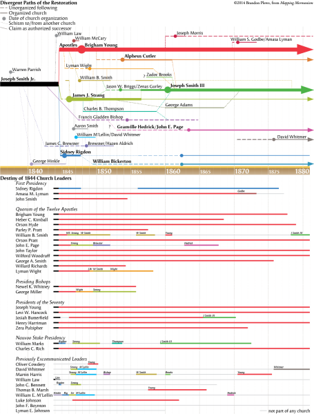
Some of these movements were able to attract hundreds of followers for short periods of time, but none had the lasting power of the major successor churches.
Brandon Plewe, Steven L. Shields
Missouri in 1830
When the Mormons arrived in western Missouri in 1831, it was the farthest American frontier, sparsely settled with towns scattered along the Mississippi and Missouri rivers. In 1821, the year Missouri became a state, Mexico was opened for American trade, and the Santa Fe Trail was born at Franklin, passing west through the Osage Indian lands of current Jackson County.

Jackson County was organized in 1826, named for General (and future president) Andrew Jackson. It was originally 80 miles long, but the southern portion was organized into Van Buren County in 1833, with some functions still dependent on Jackson County until 1835. The 1830 Indian Removal Act authorized President Andrew Jackson to establish Indian lands west of the state, where he quickly moved the Osages and others, opening Jackson and Clay Counties to immigrants, predominantly from the South.
Brandon Plewe, Max H. Parkin
Nauvoo Diorama
Nauvoo Surveys
The survey of Nauvoo departed significantly from the City of Zion Plat proposed seven years earlier. It was laid out in a grid, as were most midwestern cities of that time. However, it lacked the small lots that had been meant to build a tight-knit community, although further subdivision of lots soon increased density in the core areas of the city. It also lacked the blocks set aside for public uses and the temple. Instead, the temple block was purchased on a prominent site at the crest of the bluff, completely outside of the original Church survey. Without an official public square, outdoor civic and church meetings were typically held on an unsold block below the temple called “the Grove” or at the foot of Main Street in front of Joseph Smith’s home.

Soon after Nauvoo was surveyed, adjacent landowners quickly recognized the growth potential of the city as the gathering place for the Saints and began subdividing their property to sell to immigrants. These developers included old Commerce settlers like Daniel H. Wells and Davison Hibbard, Church members, and distant speculators. The first addition, created by Ethan Kimball, was laid out as small farms, but subsequent plats followed the Nauvoo Grid, and by 1845 almost all of Kimball’s addition had been gridded (the surveys for most of which were never officially recorded with the county).
Brandon Plewe
Orson Hyde's Mission to the Holy Land
Orson Hyde was called with fellow Apostle John E. Page at the conference of April 1840 to dedicate the Holy Land for the gathering of the Jews, and left Nauvoo for the East the next week. Page stayed behind in Ohio, but Hyde went on to Europe. After spending some time with his brethren of the Twelve on their mission in England, Hyde traveled through Europe and the Middle East, returning to Nauvoo in December 1842. Although his attempts at preaching in Germany were not successful, the intended goal in Jerusalem was accomplished. Along the way, his reports were regularly published in the Millennial Star and the Times and Seasons.
Mapping Mormonism p.47
Palmyra & Manchester
Palmyra and Manchester Townships both contained homes in which the Joseph Smith Sr. family lived, and they had extensive social, religious, and economic dealings in both townships. For example, Hyrum worked, did business, and was a member of the Presbyterian Church, Masonic fraternity, and militia in Palmyra. In Manchester he married Jerusha Barden, taught school, was a school trustee, and did business. Donald Enders
Brandon Plewe, Mapping Mormonism p.17
Palmyra, Manchester, and Fayette
Palmyra was a rapidly growing village when the Smith family moved there in 1816–17. Even when they moved south, this was still the nearest village. The Book of Mormon was printed on the press of E.B. Grandin in Palmyra, becoming available in March 1830 just before the Church was organized. Although Joseph encountered great opposition to his work, he and his family also found many believers, and a branch was formed in the area in 1830.
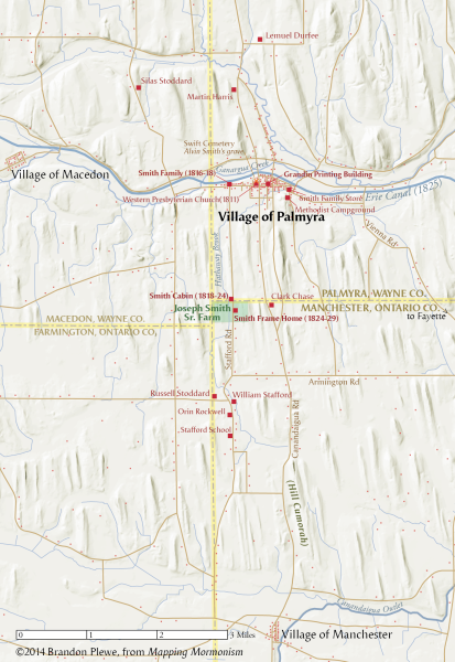
Joseph Smith Sr. and his family lived in two homes straddling the border between Palmyra and Manchester townships between 1818 and 1830. On this land in 1820, Joseph Jr. received his First Vision, and it was in the log house that he was visited by Moroni in 1823. He moved away to work in 1825 but returned in 1827 with his new bride, Emma; during their one-year stay there he obtained the gold plates, but frequent attempts to steal the plates forced them to leave. While staying here in 1829 to oversee the publication of the Book of Mormon, Joseph showed the plates to eight witnesses.
Fayette Township was the home of Peter Whitmer and his family. Early converts to Joseph’s message, they welcomed Joseph, Emma, and Oliver Cowdery when persecution heightened to the south. Here Joseph completed the translation of the Book of Mormon, the Three Witnesses received their vision of the plates (July 1829), and the Church was organized in April 1830. Larry C. Porter
Brandon Plewe, Mapping Mormonism p.21
Purchasing Commerce Illinois
The Church purchased more than 750 acres in the Commerce area in 1839, including the farms of local residents and the property of speculators who lived in Connecticut. The latter included Commerce City, a town that had been platted but had failed to sell any lots due to the Panic of 1837. The massive mortgage that Joseph Smith signed for this property was to be paid for through the sale of lots, but soon became a major personal burden for him (among the factors that led to his declaring bankruptcy in 1842). It was difficult to balance the need to charge profitable prices for lots against his desire to house the thousands of poor immigrants who were arriving and against the interests of friends and family who were competing with the Church to sell their own lots in other parts of Nauvoo. One scheme was for gathering Saints to trade the title to the property they were leaving in the east to Hotchkiss for credit against the mortgage, for which they received property in Nauvoo. However, the debts were not paid until lands owned by Smith and the Church were sold off in 1853.
Brandon Plewe, Mapping Mormonism p.55
Religious Revival in the Palmyra Area
“An Unusual Excitement on the Subject of Religion”
The spiritual tumult of the early republic touched the Joseph Smith family intimately, as evangelical revivals ignited all around them. There were at least 30 revivals, new churches, and large conferences held within 20 miles of the young teenage Joseph Smith. This competitive atmosphere left him with a profound confusion over religious truth, as evidenced by his various autobiographical accounts. Significantly, the revivals left his own family divided along denominational lines. His mother and some siblings affiliated with the Presbyterians, but his father attended no church for a prolonged period though expressing affinity for both liberal Christian theology and popular visionary culture. By his own account, young Joseph Smith Jr. was attracted to the Methodist revivals, as was Emma Hale, his future wife. J. Spencer Fluhman
Brandon Plewe, Mapping Mormonism p.19
Route of Smith Family to Palmyra
Father Smith’s determination to investigate the prospect of land in New York was not uncommon. Western New York was a classic American frontier, full of promise for those brave enough to settle in the wilds. The land had been ceded by the native Six Nations in the 1780s, and by 1801 property throughout western New York was for sale. The area grew rapidly between 1810 and 1820 at the expense of Vermont (in which sixty townships declined in population) and the rest of New England. Emigration reached its peak in the cold years of 1816 and 1817.

The exact route followed by Lucy and her family from Norwich, Vermont, to Palmyra, New York, in the winter of 1816–17 is not known precisely. They did pass through South Royalton, Vermont, where they had to leave Lucy’s mother because of an injury sustained in the overturn of a wagon. Lucy eventually dismissed their teamster Caleb Howard near Utica, New York, after he treated Joseph Jr. poorly then tried to steal her wagon. Their course took them to Syracuse along the Seneca Turnpike, then to Palmyra, where they arrived sometime in the month of January.
Brandon Plewe
Selected Travels between Ohio and Missouri
Only a few examples of the dozens of trips taken by Church members between Ohio and Missouri are shown here, demonstrating the various means of travel and transportation employed. The preferred and most comfortable mode of travel was by riverboat, but it was costly. Most of the Saints, however, regardless of whether they were traveling in groups, as a family, or individually, journeyed by wagon, carriage, or on foot, although some employed multiple means. For example, the missionaries to the Lamanites, who journeyed to western Missouri in 1830–31, traveled about half the route by foot and half by steamer (see p. 24). When Joseph Smith made his first trip from Ohio to Missouri and back during the summer of 1831, he went by wagon, canal boat, stage, steamer, and on foot. The Colesville Branch, consisting of about seventy Mormons, made their way to Missouri that same summer almost entirely by boat. In most instances, travel time between Ohio and Missouri took three to four weeks, although for those who primarily walked (e.g., Hyrum Smith and John Murdock’s 1831 mission) or who were transporting entire households by wagon (e.g., Kirtland Camp), the trip could take six to eight weeks or even longer. Alexander L. Baugh
Brandon Plewe, Mapping Mormonism p.38
Settling Northern Missouri
Population figures for the number of Mormons living in northern Missouri just prior to their expulsion from the state in 1839 are difficult to determine because no census data exists. Although some Mormon narratives mention as many as 10,000–15,000 Latter-day Saints living in the region, these figures are probably too high. More careful estimates place the number of Mormons living in Caldwell County at approximately 5,000–5,500, with another 1,000–1,250 residing in Daviess County. Additionally, perhaps another 200–250 Mormons were scattered throughout other surrounding counties (Clay, Clinton, Ray, Carroll, and Livingston) or were living in nearby unincorporated regions. Therefore, at its height, the Mormon population of northern Missouri was likely around 6,000–7,000. Alexander L. Baugh
Mapping Mormonism p.48
Sidney Rigdon's Early Ministry
Sidney Rigdon, a well-trained and experienced Baptist minister from Pittsburgh, first preached in the Western Reserve from 1820 to 1822. Returning to Pittsburgh, he became a prominent Baptist minister, but soon joined the Disciples of Christ movement of Alexander Campbell, which broke from the Baptist Church to try to restore primitive Christianity as Campbell interpreted it. Rigdon, a dynamic and profound speaker, returned to the Western Reserve in 1825 at age 33, and soon established several Campbellite branches, and had a significant influence on many more.

Following his November 1830 conversion to Joseph Smith’s Church of Christ, hundreds of his followers from these congregations were baptized. A revelation in December 1830 said that Sidney had been “sent . . . to prepare the way before me, and before Elijah . . . and thou knewest it not” (D&C 35:4).
Brandon Plewe, Karl Ricks Anderson
The 1835 Mission of the Twelve to the Northeast
During the summer of 1835, the Quorum of the Twelve undertook their first mission as a group (and their only mission with all twelve). They traveled east from Kirtland, Ohio, under the leadership of President Thomas B. Marsh. The Apostles traveled together and separately, as they found opportunities to preach; the four Apostles shown in the map kept a diary of their travels, showing the similarities and differences of their routes.
Along the way, they called together conferences in which various items of Church business could be conducted. During this mission, “conference” took on a second meaning: in addition to being meetings where Church members conducted business and received instruction, they were permanent geographical regions consisting of a dozen or more branches (the term continued until “district” gradually replaced it in the early twentieth century). The conferences also helped the missionaries in the area organize their proselytizing efforts, helping the Church transition from its earlier freelance missionary work into a more systematically organized effort. David J. Whittaker
Brandon Plewe, Mapping Mormonism p.46
The 1837 British Mission
The first mission to Britain (1837) was centered in Lancashire, where missionaries found many converts in both the cities and the country. Of the 27 known branches organized by 1839 and shown here, 19 were within 20 miles of Preston.
Brandon Plewe
The Battle of Crooked River, October 25 1838
Brandon Plewe, Mapping Mormonism p.51
The Church in Northeastern Ohio, 1831-1838
Church growth in the Kirtland, Madison, and Amherst areas began with the Lamanite missionaries (see p. 24). Sidney Rigdon’s influence led to widespread conversions in the areas in which he had preached. Growth in the Hiram area was accelerated when Joseph Smith moved there and he and Sidney were sent on their local preaching mission. All areas were impacted by seemingly constant missionary efforts. Although it is not entirely clear where branches of the Church existed in this area, especially near Kirtland, the places identified as branches were determined by researching Church periodicals, personal journals, and land records of early members.
After the widespread dissensions of 1837 and 1838, most of those loyal to Joseph left for Missouri, but enough remained to keep several branches operating, and the area actually saw a great deal of growth during the early days of Nauvoo. Karl Ricks Anderson
Brandon Plewe, Mapping Mormonism, p.28
The City of Zion Plat
The Early British Mission
During the life of Joseph Smith, the Quorum of the Twelve Apostles led two missions to the British Isles. Heber C. Kimball and Orson Hyde established the first mission (1837–38), concentrating their efforts in the area of Preston and the River Ribble Valley of Lancashire, finding about 1,500 converts.
From 1839 to1841, the second mission, nine Apostles under the leadership of Brigham Young consolidated the success of the first mission, then expanded south into the Staffordshire potteries, Birmingham, Herefordshire, and eventually London. Orson Pratt went north to Scotland, while John Taylor opened the Isle of Man and northern Ireland. Meanwhile, Parley P. Pratt took charge of the Millennial Star newspaper, laying the foundation for a British publishing program that would become very important to the Church.
The success of these two missions had a great impact on the Church, establishing one of the most important missionary programs in the nineteenth century and an organized emigration program that would continue to provide convert-settlers for the extensive colonization and settlement of the American West. Their work prepared them for the leadership roles they would take on after the death of Joseph Smith in 1844, as well as providing a cadre of converts who were loyal to the Twelve over all other claimants to Church leadership. David J. Whittaker
Brandon Plewe, Mapping Mormonism p.47
The First Exodus: New York to Kirtland
After the revelation was given to gather to Ohio (D&C 37), each of the three New York branches departed as soon as possible. The Colesville Branch gathered in Ithaca, New York, in April 1831, where they traveled by boat across Cayuga Lake. The Fayette Branch, about 50 in number, traveled in two companies under the direction of Lucy Mack Smith and Thomas B. Marsh. Both the Colesville and Fayette companies rode barges down the Cayuga and Seneca Canal (completed 1828) to the Erie Canal, riding it to Buffalo, there boarding a steamship across Lake Erie (still icy in May) to Fairport Harbor, Ohio, the nearest port to Kirtland.
About 50 of the Palmyra/Manchester Saints, under the leadership of Martin Harris, made a similar journey soon after, arriving in Kirtland in time to attend the June 1831 conference. Susan Easton Black
Brandon Plewe, Mapping Mormonism p.25
The First Missionaries
Before the Book of Mormon was fully printed and bound, early believers carried excerpts hundreds of miles to share with relatives and friends. Thomas B. Marsh carried 16 loose pages of the Book of Mormon to Charlestown, Massachusetts, to read to his family. Solomon Chamberlain took 64 pages to Canada. After traveling 800 miles through the Canadian wilderness, he stated, “I exhorted all people to prepare for the great work of God that was now about to come forth.”
The missionaries to the Lamanites journeyed from New York to Missouri sharing the word of God with Native Americans and others. Joseph Smith Sr. and Don Carlos Smith traveled to St. Lawrence County, New York, to share the Book of Mormon with relatives. Hyrum Smith traveled to Colesville and Fayette, New York, to preach to early converts. Samuel Smith and Orson Pratt journeyed from New York to Kirtland, Ohio, to preach the word of God. The results of these missionary labors were the formation of major branches of the Church in New York and Ohio in 1830. Susan Easton Black
Brandon Plewe, Mapping Mormonism p.25
The Illinois Frontier
After statehood in 1818, Illinois’s population was concentrated in the south and near St. Louis. Much of the land west of the Illinois River was granted to veterans of the War of 1812, but few settled there due to the remaining American Indians.

After the Black Hawk War (1832), lands in western Illinois and eastern Iowa (including the Half-Breed Tract across from Nauvoo) were available for white settlement, and the frontier rapidly expanded northward (and west from Indiana).

Land speculation by easterners (e.g., the Hotchkiss and Kimball groups) and locals (e.g., Isaac Galland) was rampant in this frontier environment, leading to many “paper towns” like Commerce City, and land title that was often dubious.
Brandon Plewe, Donald Q. Cannon
The Kirtland Temple
The most prominent Kirtland structure (then and now) is the stately House of the Lord, the first Latter-day Saint temple. It overlooks the city from the top of the hill. The design, measurements, and functions of the Kirtland Temple were given by revelation. Its interior was to be 55 feet wide and 65 feet long and to have a lower and a higher court. The lower part of the inner court was to be dedicated “for your Sacrament offering, and for your preaching, and your fasting, and your praying, and the offering up of your most holy desires unto me, saith your Lord.” The higher part of the inner court was to be “dedicated unto me for the school of mine apostles” (D&C 95:13–17).
The external design of the Kirtland Temple is typical of New England Protestant meetinghouses, but the arrangement of the interior is unique. On each of the two main floors are two series of four-tiered pulpits, one on the west side, the other on the east. These are symbolic of the offices of the Melchizedek and Aaronic Priesthoods and accommodated their presidencies. The third floor contained offices and school facilities.
The Saints completed the temple in less than three years. The cornerstone was laid at the southeast corner on July 23, 1833, and the temple was dedicated on March 17, 1836. The temple became the center of life for the Saints, housing the School of the Prophets and Elders. There are three important revelations associated with the Kirtland Temple: D&C 109, 110, and 137. The last records the visit of the Father and the Son. “The heavens were opened upon us, and I beheld the celestial kingdom of God” and saw “the blazing throne of God, whereon was seated the Father and the Son” (D&C 137:1, 3).
Brandon Plewe and Bret Miller, Mapping Mormonism p.31
The Martyrdom in Carthage Jail
(1) June 25: Joseph and Hyrum are held at the Carthage Jail to await trial for treason, staying in the Debtor's Apartment (downstairs).
(2) June 26: The men are moved to the higher security "dungeon" for their protection.
(3) Due to the heat, they are allowed to sleep in the jailer's bedroom.
June 27, 4:30pm: a mob begins to gather in the street.
(4) 5:12pm: Several men burst into the jail, finding the guards missing and the door unlocked. The remainder stand outside shooting into the windows.
5:13pm: a shot through the door kills Hyrum.
(5) 5:14pm: Joseph attempts to hold the door shut, but it is forced partially open. John Taylor flees to the open window, but a shot in chest forces him back in, where he rolls under the bed.
(6) 5:15pm: Willard Richards pushes on the door, knocking down gun barrels with his cane, while Joseph runs for the window. Joseph is shot from the front and rear and falls out the window.
(7) The mob rushes outside to see Joseph.
(8) Richards drags the wounded Taylor into the dungeon and hides him under the mattress.
(9) Coming back in, mobsters see Richards in the dungeon doorway, but someone yells "The Mormons are coming" and the mob disperses, sparing his life. Kenneth W. Godfrey
Brandon Plewe, Mapping Mormonism p.63
The Mormon-Missouri War
The Mormon–Missouri War was precipitated by Missourian fears that the rapidly immigrating Mormons would dominate not only Caldwell County, which had been set aside for Mormon settlement, but also Daviess County, which was supposed to be a non-Mormon County, then continue to expand into surrounding counties. The Missourians were especially anxious about political control, leading to a skirmish on election day in August at the polls in Gallatin.

Both sides felt slighted by the fight, and heated rhetoric soon gave way to raids on homes. This in turn led to more violent retaliatory strikes by both sides, culminating in the Battle of Crooked River and the Hawn’s Mill Massacre. Biased reports of the fighting painted a picture of Mormons in open rebellion against the Missouri government.
Brandon Plewe, Sean Cannon
The Nauvoo Temple
In January 1841, Joseph Smith received a revelation (D&C 124) commanding the Saints to build a temple in Nauvoo. The temple, a magnificent edifice for its day, was erected by a people who had very few financial resources. In place of monetary donations, members tithed their time to work on the building. Like the Kirtland Temple, most of the space was dedicated to public Church meetings; endowment and sealing ceremonies were reserved for the attic story. After Joseph’s martyrdom, finishing the temple was the primary goal of the Church. It was dedicated even as the Saints were leaving for the West.

The LDS Church has recently reconstructed the original Nauvoo Temple on the original temple site. The new building has the same exterior but an interior in keeping with modern temple designs. The new temple is as much a tourist attraction as a functional building (see p. 136), helping visitors visualize the city of Nauvoo as it once was.
Brandon Plewe, Mapping Mormonism p.56
The Smith Family in Vermont
The parents of Joseph Smith and Lucy Mack had settled in the frontier of Vermont and New Hampshire in the early 1790s; it was here that the couple began to raise their family. Due to recurring financial troubles and failed ventures, the growing family was forced to move nine times in 20 years. In most places, Joseph purchased or rented land to farm, except for an attempt at being a merchant in Randolph. Their moves frequently took them back to his parents’ land in Tunbridge or her parents’ land on the border of Sharon and Royalton. It was while living at the latter that the future prophet Joseph Jr. was born. An epidemic of typhoid hit the family in 1813 during their time in Lebanon, New Hampshire; this led to a serious leg infection in young Joseph, who may have died if not for the latest medical practices being pioneered at nearby Dartmouth College. Larry C. Porter
Brandon Plewe, Mapping Mormonism p.14
The Smith Farm in Manchester New York
This is a south-facing view of the Smith Farm in Manchester in about 1829. Between 1820 and 1825, the family cleared 60 acres of the 100-acre Manchester land, planted an orchard, created cultivated fields and meadows, dug wells, built a frame home, fenced, and produced 1,000 pounds of maple sugar annually. In the township the farm was above average for size and value per acre and known for “its good order and industry.” The Palmyra property, 80 acres, was eventually purchased by Hyrum, who partially cleared and fenced it. On it was a cooper’s shop, animal shelter, corral, and well. Hyrum had cows and raised corn and beans. He was also taxed for five acres in Manchester. However, the Smiths never finished paying for either property. Donald Enders
Brandon Plewe, Mapping Mormonism p.16
The Travels of Joseph Smith Jr.
Joseph Smith traveled far more extensively than many might assume. During his short life he traveled mostly in the eastern United States, but he also visited Canada at least twice. He and his family resided in six states, and he traveled in sixteen states. His travels took him to large cities such as Boston, New York City, Philadelphia, and Washington, D.C. He also visited smaller cities such as Salem, Massachusetts; Providence, Rhode Island; Albany, New York; and Springfield and Quincy, Illinois. Along his way, he visited dozens of towns and villages across the eastern United States.

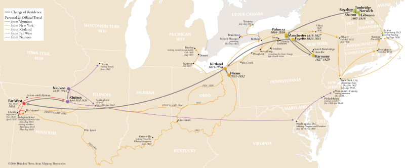
As he traveled, Joseph Smith employed several common modes of transportation. He walked, rode horseback, traveled by wagon and team, journeyed by stage coach, sailed on river boats and canal barges, and even traveled by rail.
Brandon Plewe, Donald Q. Cannon
Timeline of Restoration Scriptures
Brandon Plewe, Mapping Mormonism p.22-23
Timeline of the Restoration, 1823-1830
Brandon Plewe, Mapping Mormonism p.20
Zions Camp
Zion’s Camp was a Mormon military expedition company that marched to Missouri in 1834, intending to help the Saints reclaim the lands in Jackson County from which they had been expelled in November 1833.
On May 1, 1834, a group of 20 men left Kirtland. Five days later, the main company of 85 men under the leadership of Joseph Smith departed. The same day, Hyrum Smith and Lyman Wight led a smaller group of seventeen persons from Pontiac, Michigan, intending to join with the main body en route. As the company proceeded west, additional men and volunteers fell in with the main company, increasing their ranks and numbers. On June 8, following a month of travel through Ohio, Indiana, and Illinois, picking up recruits along the way, the two groups met at the Salt River Branch in Monroe County, Missouri. Now Zion’s Camp consisted of a force of just over 200 men. In the meantime, the Mormons learned that Missouri Governor Daniel Dunklin would not lend state military assistance as promised and advised the Saints to seek redress through the courts. Dunklin’s position meant that the main objective of Zion’s Camp—to help the Saints repossess their Jackson County property—could not be achieved.
In late June, after arriving in Clay County where the main body of Missouri Saints had located, Joseph Smith received revelatory instructions informing the members of Zion’s Camp that they should disband and return to their homes in the East. On July 3, the men were officially discharged. Members did not return to Ohio in one large body but made their way home in smaller groups. Before beginning the return trip, Joseph Smith spent a few days in Clay County instructing the leaders and organizing a stake in Missouri (see p. 34). He left around July 12, arriving back in Kirtland around August 1, after nearly a three-month absence. Alexander L. Baugh
Brandon Plewe, Mapping Mormonism p.39

The Restoration of the Church of Jesus Christ through the Prophet Joseph Smith created a geographic imprint upon which we can still trace the people, places, and events that were fundamental to the Church. The migration of Joseph’s ancestors first led them to New England and later to upstate New York, as the Erie Canal provided access to better lands to the west. The differing Protestant religious backgrounds of the newly arriving migrants created a social milieu that influenced the spiritual development of Joseph, while the unique geography of the upstate New York area, created by glaciation south of the Great Lakes, contained places that figured centrally in the sacred experiences of the boy prophet.

Following the organization of the Church in 1830, Joseph and new members and officers joined the westward movement of Americans to the Ohio, Mississippi, and Missouri river valleys, where they colonized the fertile land, founded communities, and ultimately came into conflict with other settlers of the region. In less than 15 years the Prophet Joseph and early missionaries crisscrossed the Mississippi–Ohio valley and traveled to the East Coast and Europe in their missionary journeys and in ministering to the congregations of the new faith. The geography they created included numerous farms, towns, two temples, and even the large city of Nauvoo. Within this new geography, sacred events occurred that resonate through the Church of Jesus Christ even today, including the revelation and translation of scriptures that are part of the standard works Church members revere as holy.