Come Follow Me Skip to main content
An Atlas of Latter-day Saint History

Come Follow Me

Selected graphics to aid your study of Church History at home and in Sunday School

Every four years, the Come Follow Me personal and Sunday School study program focuses on the Doctrine and Covenants, along with Church History. We have selected some graphics from Mapping Mormonism to support your study. NEW FOR 2025: The graphics are now full print quality!

You are welcome to use these graphics for personal study and Sunday School lessons. However, they are copyrighted, and you may not redistribute them on another website or publication, alter them in any way, or use them for any other purpose, without consent of the book editors.

Weeks 1-2: The Restoration and the Doctrine and Covenants (Section 1)

Timeline of Restoration Scripture Publication

Timeline of Restoration Scriptures
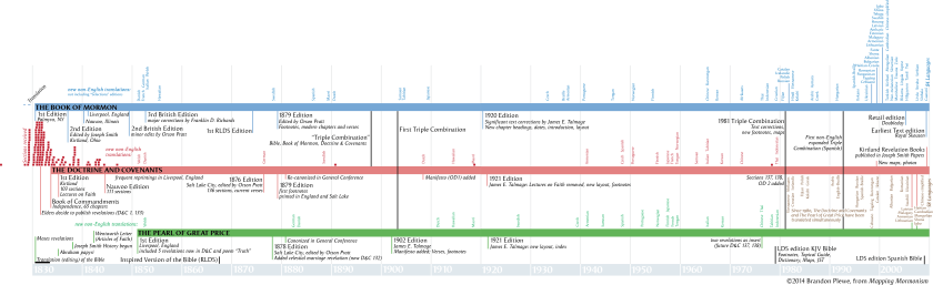
Photo by Brandon Plewe, Mapping Mormonism p.22-23

Locations of Revelations in the Doctrine and Covenants

Locations of Revelations in the Doctrine and Covenants
The history of the Doctrine and Covenants mirrors the early history of the Church. The earliest revelations, through 1830, are from the Church’s New York–Pennsylvania period. When Joseph Smith and his followers moved to northeast Ohio in 1831, that area became the focal point of the Prophet’s revelatory work. Half of the sections in the Doctrine and Covenants were received during Joseph’s seven-year stay there, evidence of the rapid development of Church doctrine and practice during that period. Meanwhile, Latter-day Saints began to colonize western Missouri, so during the 1830s, revelations were divided between the two gathering places. Revelations received in western Illinois in the first half of the 1840s reflect the Church’s establishment of a new gathering place there, from which the Saints were ultimately driven to the Great Basin in the American West. Kent P. Jackson
Photo by Brandon Plewe, Mapping Mormonism p.23

Week 3: The Smith Family and the First Vision (1805-1820, JS-H 1:1-26)

Smith Ancestors

Joseph Smith's Ancestry
The migrations of the Smith and Mack families reflect some of the main themes of New England history before 1830. Solomon Mack, Joseph Smith’s maternal grandfather, came of age in Lyme, Connecticut, and spent his teenage years in hard agricultural labor. A veteran of the French and Indian and Revolutionary wars, Mack married Lydia Gates in 1759 and spent most of his adult life in various money-making ventures. After a long series of adventures and disappointments, Mack experienced a Christian conversion late in life. Lydia, who had joined a Congregational church in adulthood, had been the primary religious influence in the lives of the children. The Macks’ youngest child, Lucy, met Joseph Smith, son of Asael and Mary Duty Smith, on a visit to a brother in Tunbridge, Vermont. The Smiths had lived in Topsfield, Massachusetts, for four generations; but Asael, the youngest of five children and lacking an inheritance in land, left the village in search of a living in early adulthood. After several attempts at farming in eastern Massachusetts and New Hampshire, the Smiths settled in Vermont in 1791. Asael and some of his family, including Joseph Smith Sr., were drawn to Universalism, a liberal Christian movement that emphasized God’s reasonableness and the “universal” salvation of the human family. The Joseph and Lucy Smith family also moved several times in search of economic stability (see p. 14) and, like their ancestors, found themselves caught between the Calvinist orthodoxy of New England’s traditionally dominant churches and the heterodox doctrines of Universalism. J. Spencer Fluhman
Photo by Brandon Plewe, Mapping Mormonism p.12

The Smiths in Vermont

The Smith Family in Vermont
The parents of Joseph Smith and Lucy Mack had settled in the frontier of Vermont and New Hampshire in the early 1790s; it was here that the couple began to raise their family. Due to recurring financial troubles and failed ventures, the growing family was forced to move nine times in 20 years. In most places, Joseph purchased or rented land to farm, except for an attempt at being a merchant in Randolph. Their moves frequently took them back to his parents’ land in Tunbridge or her parents’ land on the border of Sharon and Royalton. It was while living at the latter that the future prophet Joseph Jr. was born. An epidemic of typhoid hit the family in 1813 during their time in Lebanon, New Hampshire; this led to a serious leg infection in young Joseph, who may have died if not for the latest medical practices being pioneered at nearby Dartmouth College. Larry C. Porter
Photo by Brandon Plewe, Mapping Mormonism p.14

The Smith Farm

The Smith Farm in Manchester New York
This is a south-facing view of the Smith Farm in Manchester in about 1829. Between 1820 and 1825, the family cleared 60 acres of the 100-acre Manchester land, planted an orchard, created cultivated fields and meadows, dug wells, built a frame home, fenced, and produced 1,000 pounds of maple sugar annually. In the township the farm was above average for size and value per acre and known for “its good order and industry.” The Palmyra property, 80 acres, was eventually purchased by Hyrum, who partially cleared and fenced it. On it was a cooper’s shop, animal shelter, corral, and well. Hyrum had cows and raised corn and beans. He was also taxed for five acres in Manchester. However, the Smiths never finished paying for either property. Donald Enders
Photo by Brandon Plewe, Mapping Mormonism p.16

Palmyra & Manchester

Palmyra & Manchester
Palmyra and Manchester Townships both contained homes in which the Joseph Smith Sr. family lived, and they had extensive social, religious, and economic dealings in both townships. For example, Hyrum worked, did business, and was a member of the Presbyterian Church, Masonic fraternity, and militia in Palmyra. In Manchester he married Jerusha Barden, taught school, was a school trustee, and did business. Donald Enders
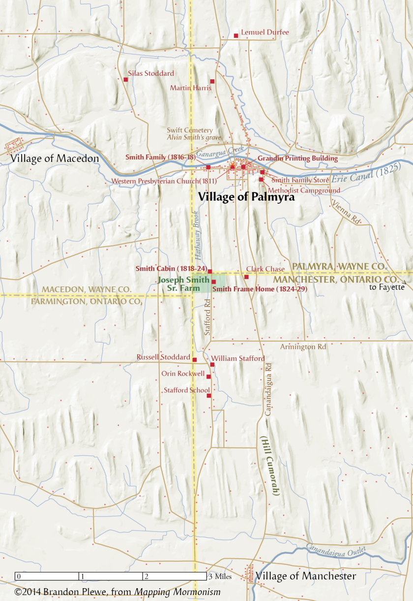
Photo by Brandon Plewe, <em>Mapping Mormonism</em> p.17

Religious Revivals

Religious Revival in the Palmyra Area
“An Unusual Excitement on the Subject of Religion”
The spiritual tumult of the early republic touched the Joseph Smith family intimately, as evangelical revivals ignited all around them. There were at least 30 revivals, new churches, and large conferences held within 20 miles of the young teenage Joseph Smith. This competitive atmosphere left him with a profound confusion over religious truth, as evidenced by his various autobiographical accounts. Significantly, the revivals left his own family divided along denominational lines. His mother and some siblings affiliated with the Presbyterians, but his father attended no church for a prolonged period though expressing affinity for both liberal Christian theology and popular visionary culture. By his own account, young Joseph Smith Jr. was attracted to the Methodist revivals, as was Emma Hale, his future wife. J. Spencer Fluhman
Photo by Brandon Plewe, Mapping Mormonism p.19

Weeks 4-10: Translation and Priesthood (1823-1829, D&C 2-19; JS-H 1:27-75)

Western New York

Joseph Smith's Travels in Western New York
Western New York was a rapidly developing frontier between 1820 and 1830, as the woodland was cleared for farms and new towns sprang up. Toll turnpikes and the Erie Canal (completed in 1825) connected the towns. Although his exact route is not always known, Joseph Smith traveled the 100 miles connecting west-central and south-central New York through Ithaca more than 20 times, either by foot or by wagon (the latter often borrowed from friends). Larry C. Porter
Photo by Brandon Plewe, Mapping Mormonism, p.21

Palmyra, Manchester, Fayette

Palmyra, Manchester, and Fayette
Palmyra was a rapidly growing village when the Smith family moved there in 1816–17. Even when they moved south, this was still the nearest village. The Book of Mormon was printed on the press of E.B. Grandin in Palmyra, becoming available in March 1830 just before the Church was organized. Although Joseph encountered great opposition to his work, he and his family also found many believers, and a branch was formed in the area in 1830.
Joseph Smith Sr. and his family lived in two homes straddling the border between Palmyra and Manchester townships between 1818 and 1830. On this land in 1820, Joseph Jr. received his First Vision, and it was in the log house that he was visited by Moroni in 1823. He moved away to work in 1825 but returned in 1827 with his new bride, Emma; during their one-year stay there he obtained the gold plates, but frequent attempts to steal the plates forced them to leave. While staying here in 1829 to oversee the publication of the Book of Mormon, Joseph showed the plates to eight witnesses.
Fayette Township was the home of Peter Whitmer and his family. Early converts to Joseph’s message, they welcomed Joseph, Emma, and Oliver Cowdery when persecution heightened to the south. Here Joseph completed the translation of the Book of Mormon, the Three Witnesses received their vision of the plates (July 1829), and the Church was organized in April 1830. Larry C. Porter
Photo by Brandon Plewe, Mapping Mormonism p.21

Bainbridge, Colesville, and Harmony

Bainbridge, Colesville, and Harmony
Near the village of South Bainbridge (now Afton) was the home of Josiah Stowell, a well-to-do farmer who hired Joseph Smith and his father to look for a rumored Spanish silver mine in Harmony. Although the search was unproductive, Joseph continued to work at the Stowell farm during 1826 while he courted Emma Hale. The two were married in South Bainbridge in January 1827.
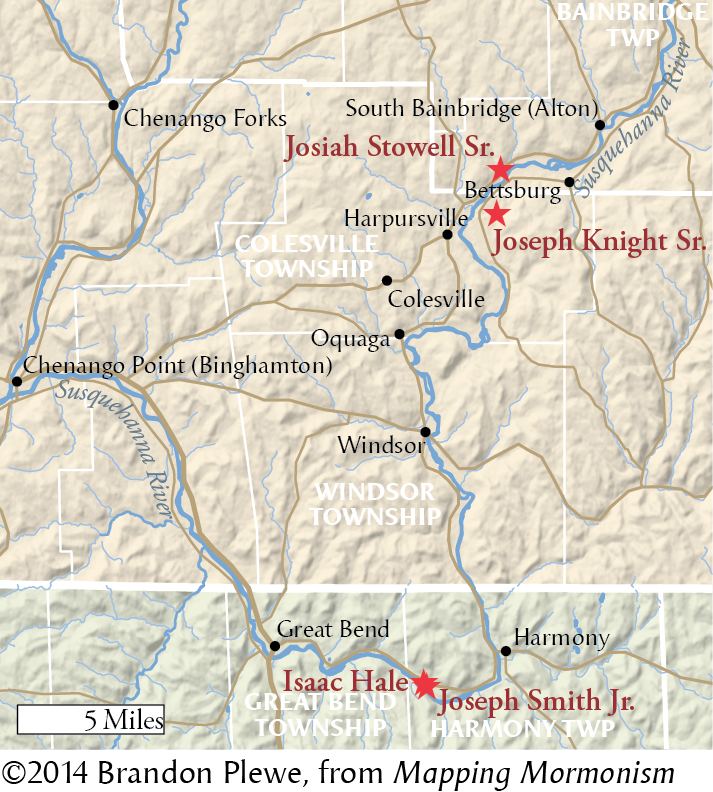
Colesville Township contained the farm of Joseph Knight Sr., who also employed Joseph Smith Jr. in 1826. Knight and his family were quickly converted to Joseph’s teachings, often supporting him during the translation as well. Many of their friends also believed, but enough people opposed Joseph that he was taken to court (and acquitted) here at least twice. In June 1829, the Melchizedek Priesthood was restored somewhere between here and Harmony. In 1830, one of the first branches of the newly organized Church of Christ was created at the Knight farm.
Harmony Township (now Oakland) was first visited by Joseph Smith Jr. when he boarded at the home of Isaac Hale while employed by Josiah Stowell to search for a silver mine in early November 1825. Rather than precious metal, Joseph discovered Hale’s daughter Emma. Hale never believed Joseph’s stories of his visions and opposed their marriage, but he eventually sold Joseph and Emma a portion of his farm along the Susquehanna River. This was their primary residence for most of 1828–30, and here Joseph (with Emma, Martin Harris, and Oliver Cowdery) translated most of the Book of Mormon and received the Aaronic Priesthood in 1829. Joseph and Emma were still residing here in 1830, when Joseph began retranslating the Bible. Larry C. Porter
Photo by Brandon Plewe, Mapping Mormonism p.21

Timeline of the Restoration

Timeline of the Restoration, 1823-1830
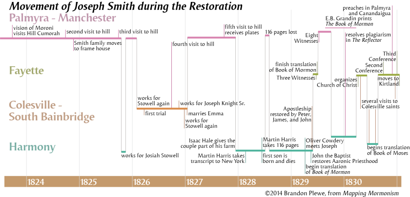
Photo by Brandon Plewe, Mapping Mormonism p.20

Weeks 11-17: The First Year (1830, D&C 20-40)

The First Missionaries

The First Missionaries
Before the Book of Mormon was fully printed and bound, early believers carried excerpts hundreds of miles to share with relatives and friends. Thomas B. Marsh carried 16 loose pages of the Book of Mormon to Charlestown, Massachusetts, to read to his family. Solomon Chamberlain took 64 pages to Canada. After traveling 800 miles through the Canadian wilderness, he stated, “I exhorted all people to prepare for the great work of God that was now about to come forth.”
The missionaries to the Lamanites journeyed from New York to Missouri sharing the word of God with Native Americans and others. Joseph Smith Sr. and Don Carlos Smith traveled to St. Lawrence County, New York, to share the Book of Mormon with relatives. Hyrum Smith traveled to Colesville and Fayette, New York, to preach to early converts. Samuel Smith and Orson Pratt journeyed from New York to Kirtland, Ohio, to preach the word of God. The results of these missionary labors were the formation of major branches of the Church in New York and Ohio in 1830. Susan Easton Black
Photo by Brandon Plewe, Mapping Mormonism p.25

Origins of Early Church Leaders

Birthplaces of Early Church Leaders
Included here are members of the First Presidency, Quorum of Twelve Apostles, First Seven Presidents of the Seventy, Stake Presidencies, Three Witnesses, Presiding Bishops, and Patriarchs (Seventies were not General Authorities until 1976). There is an obvious predominance of leaders from New England and upstate New York; this led to a definite New England culture in the early Church. Of the leaders shown here whose previous religious affiliations are known, fourteen had associated with Methodism, eight with Congregationalism, seven with Alexander Campbell’s “restoration” movement (eventually called the “Disciples of Christ”), six with the Baptists, three with Presbyterianism, three with Unitarianism or Universalism, and one each for Anglicanism, Quakerism, Shakerism, and Lutheranism. Some leaders had multiple religious affiliations before joining with the Latter-day Saints; others had none. J. Spencer Fluhman
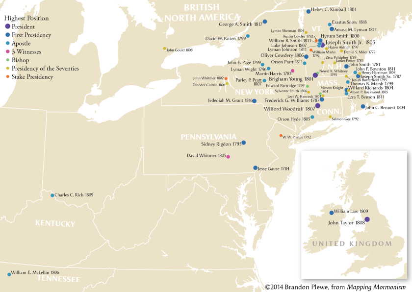
Photo by Brandon Plewe, Mapping Mormonism p.13

Gathering to "the Ohio"

The First Exodus: New York to Kirtland
After the revelation was given to gather to Ohio (D&C 37), each of the three New York branches departed as soon as possible. The Colesville Branch gathered in Ithaca, New York, in April 1831, where they traveled by boat across Cayuga Lake. The Fayette Branch, about 50 in number, traveled in two companies under the direction of Lucy Mack Smith and Thomas B. Marsh. Both the Colesville and Fayette companies rode barges down the Cayuga and Seneca Canal (completed 1828) to the Erie Canal, riding it to Buffalo, there boarding a steamship across Lake Erie (still icy in May) to Fairport Harbor, Ohio, the nearest port to Kirtland.
About 50 of the Palmyra/Manchester Saints, under the leadership of Martin Harris, made a similar journey soon after, arriving in Kirtland in time to attend the June 1831 conference. Susan Easton Black
Photo by Brandon Plewe, Mapping Mormonism p.25

Weeks 18-21: Establishing Kirtland (1831, D&C 41-50)

The Church in Northeastern Ohio

The Church in Northeastern Ohio, 1831-1838
Church growth in the Kirtland, Madison, and Amherst areas began with the Lamanite missionaries (see p. 24). Sidney Rigdon’s influence led to widespread conversions in the areas in which he had preached. Growth in the Hiram area was accelerated when Joseph Smith moved there and he and Sidney were sent on their local preaching mission. All areas were impacted by seemingly constant missionary efforts. Although it is not entirely clear where branches of the Church existed in this area, especially near Kirtland, the places identified as branches were determined by researching Church periodicals, personal journals, and land records of early members.
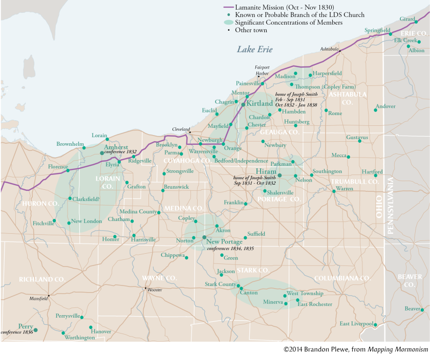
After the widespread dissensions of 1837 and 1838, most of those loyal to Joseph left for Missouri, but enough remained to keep several branches operating, and the area actually saw a great deal of growth during the early days of Nauvoo. Karl Ricks Anderson
Photo by Brandon Plewe, Mapping Mormonism, p.28

Kirtland in 1837

Kirtland in 1837
Initially, the focus of the village was in “the flats” south of the Chagrin River. At this time, the Newel K. Whitney store at the crossroads was essentially the headquarters of the Church: Joseph Smith had an office there, and the School of the Prophets—a training program for priesthood leaders and missionaries—was held upstairs.
By 1835, a new city was emerging on “the Bluffs” to the south, centered on the temple and following the planned grid pattern of the City of Zion. However, only a few of the 225 planned blocks (covering an area twice the size of this map) were developed before disaffected Church leaders drove Joseph out of Kirtland, along with most of the members of the Church loyal to him.
It should be noted that this reconstruction is not entirely certain. Some features have survived to the present (including the temple and the Whitney store); many locations are known from extensive historical and archaeological evidence, but some homes shown here are only conjectures based on general statements of the geography of Kirtland. Mark L. Staker
Photo by Brandon Plewe, Mapping Mormonism p.31

Weeks 22-24, 37: Establishing and Abandoning Zion (1831-1833, D&C 51-63, 98-101)

Independence in 1833

Independence Missouri in 1833
A view of Independence at the height of Mormon settlement, looking toward the southwest. The white outline shows the original plat of the town of Independence, while yellow outlines show LDS purchases in town and to the west. Independence was established in 1827, two years after the Osage Tribe ceded Missouri’s western strip to the state. The old Osage Trace became the route to Santa Fe, passing west through the upper edge of the county and through Independence, where it branched. The western link, called the Westport Road, extended to the Native American lands to the west and also gave the Mormons access to their settlements in Kaw Township. Independence, which Washington Irving observed to be a “little straggling frontier village” in 1832, was primarily peopled by hearty frontier men from the southern states. These settlers cleared their timbered lots, planted corn fields, built rustic houses, and opened businesses. The two nearby river landings (Independence Landing two miles north and Blue Mills Landing six miles northeast) brought to the village adventurers, Indian traders, trappers, explorers, and those who had reason to break loose from the constraints of civilization. Max H. Parkin
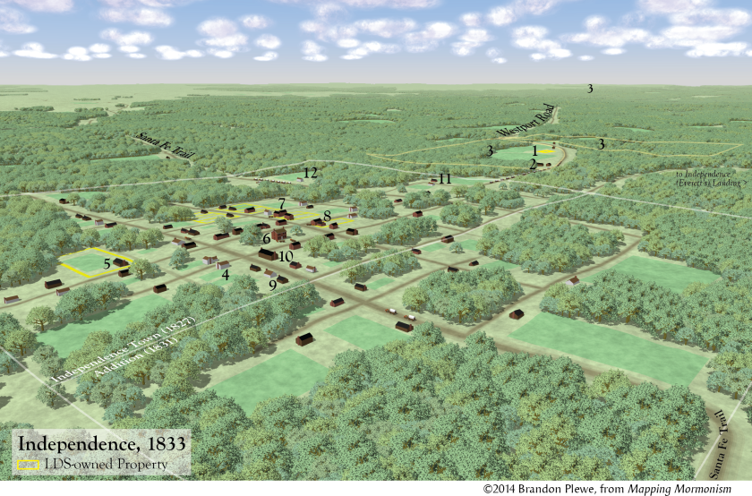
Photo by Brandon Plewe, Mapping Mormonism, p.33

Jackson and Clay Counties, Missouri

Jackson and Clay Counties, Missouri
While most of the population of Jackson and Clay counties lived on scattered homesteads in the woodland fringe, Latter-day Saints established dense communities (five in Jackson County 1831–33, several more in Clay County 1834–36).
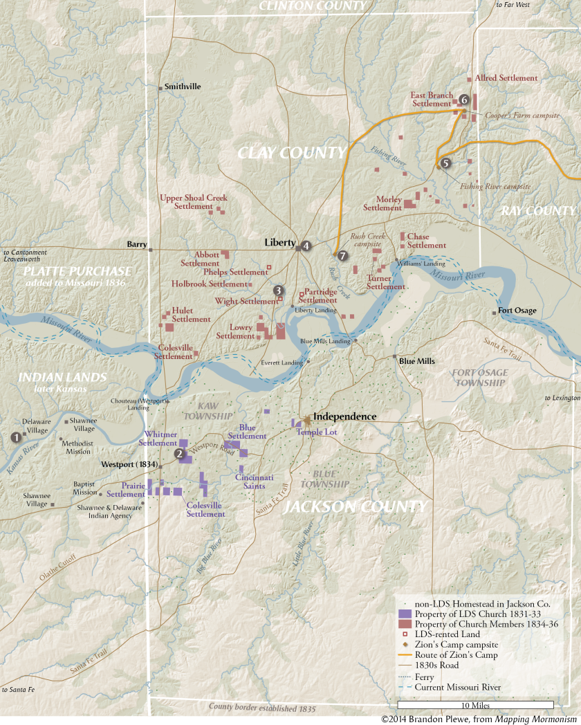
Photo by Brandon Plewe, Mapping Mormonism p.35

Ohio-Missouri Journeys

Selected Travels between Ohio and Missouri
Only a few examples of the dozens of trips taken by Church members between Ohio and Missouri are shown here, demonstrating the various means of travel and transportation employed. The preferred and most comfortable mode of travel was by riverboat, but it was costly. Most of the Saints, however, regardless of whether they were traveling in groups, as a family, or individually, journeyed by wagon, carriage, or on foot, although some employed multiple means. For example, the missionaries to the Lamanites, who journeyed to western Missouri in 1830–31, traveled about half the route by foot and half by steamer (see p. 24). When Joseph Smith made his first trip from Ohio to Missouri and back during the summer of 1831, he went by wagon, canal boat, stage, steamer, and on foot. The Colesville Branch, consisting of about seventy Mormons, made their way to Missouri that same summer almost entirely by boat. In most instances, travel time between Ohio and Missouri took three to four weeks, although for those who primarily walked (e.g., Hyrum Smith and John Murdock’s 1831 mission) or who were transporting entire households by wagon (e.g., Kirtland Camp), the trip could take six to eight weeks or even longer. Alexander L. Baugh
Photo by Brandon Plewe, Mapping Mormonism p.38

Weeks 30, 31, 39: Maturing Church Administration (1832-1835, D&C 81-84, 106-108)

Ohio-Missouri Era Organization

Church Organization in the Kirtland-Missouri Era
During the 1830s, ecclesiastical quorums, councils, and offices were established to administer the spiritual and temporal affairs of the Church. At the organization of the Church in 1830, leadership was simple: Joseph Smith and Oliver Cowdery presided over the Church as first and second elders. Over the next several years, the numerical and geographical growth of the Church necessitated a more complex leadership structure.
Photo by Brandon Plewe, Mapping Mormonism p.39

First Mission of the Twelve Apostles, 1835

The 1835 Mission of the Twelve to the Northeast
During the summer of 1835, the Quorum of the Twelve undertook their first mission as a group (and their only mission with all twelve). They traveled east from Kirtland, Ohio, under the leadership of President Thomas B. Marsh. The Apostles traveled together and separately, as they found opportunities to preach; the four Apostles shown in the map kept a diary of their travels, showing the similarities and differences of their routes.
Along the way, they called together conferences in which various items of Church business could be conducted. During this mission, “conference” took on a second meaning: in addition to being meetings where Church members conducted business and received instruction, they were permanent geographical regions consisting of a dozen or more branches (the term continued until “district” gradually replaced it in the early twentieth century). The conferences also helped the missionaries in the area organize their proselytizing efforts, helping the Church transition from its earlier freelance missionary work into a more systematically organized effort. David J. Whittaker
Photo by Brandon Plewe, Mapping Mormonism p.46

Weeks 36, 40: The Kirtland Temple (1833-1836, D&C 94-97, 109-110)

Kirtland Temple

The Kirtland Temple
The most prominent Kirtland structure (then and now) is the stately House of the Lord, the first Latter-day Saint temple. It overlooks the city from the top of the hill. The design, measurements, and functions of the Kirtland Temple were given by revelation. Its interior was to be 55 feet wide and 65 feet long and to have a lower and a higher court. The lower part of the inner court was to be dedicated “for your Sacrament offering, and for your preaching, and your fasting, and your praying, and the offering up of your most holy desires unto me, saith your Lord.” The higher part of the inner court was to be “dedicated unto me for the school of mine apostles” (D&C 95:13–17).
The external design of the Kirtland Temple is typical of New England Protestant meetinghouses, but the arrangement of the interior is unique. On each of the two main floors are two series of four-tiered pulpits, one on the west side, the other on the east. These are symbolic of the offices of the Melchizedek and Aaronic Priesthoods and accommodated their presidencies. The third floor contained offices and school facilities.
The Saints completed the temple in less than three years. The cornerstone was laid at the southeast corner on July 23, 1833, and the temple was dedicated on March 17, 1836. The temple became the center of life for the Saints, housing the School of the Prophets and Elders. There are three important revelations associated with the Kirtland Temple: D&C 109, 110, and 137. The last records the visit of the Father and the Son. “The heavens were opened upon us, and I beheld the celestial kingdom of God” and saw “the blazing throne of God, whereon was seated the Father and the Son” (D&C 137:1, 3).
Photo by Brandon Plewe and Bret Miller, Mapping Mormonism p.31

Week 38: Zion's Camp (1834, D&C 102-105)

Zion's Camp

Zions Camp
Zion’s Camp was a Mormon military expedition company that marched to Missouri in 1834, intending to help the Saints reclaim the lands in Jackson County from which they had been expelled in November 1833.
On May 1, 1834, a group of 20 men left Kirtland. Five days later, the main company of 85 men under the leadership of Joseph Smith departed. The same day, Hyrum Smith and Lyman Wight led a smaller group of seventeen persons from Pontiac, Michigan, intending to join with the main body en route. As the company proceeded west, additional men and volunteers fell in with the main company, increasing their ranks and numbers. On June 8, following a month of travel through Ohio, Indiana, and Illinois, picking up recruits along the way, the two groups met at the Salt River Branch in Monroe County, Missouri. Now Zion’s Camp consisted of a force of just over 200 men. In the meantime, the Mormons learned that Missouri Governor Daniel Dunklin would not lend state military assistance as promised and advised the Saints to seek redress through the courts. Dunklin’s position meant that the main objective of Zion’s Camp—to help the Saints repossess their Jackson County property—could not be achieved.
In late June, after arriving in Clay County where the main body of Missouri Saints had located, Joseph Smith received revelatory instructions informing the members of Zion’s Camp that they should disband and return to their homes in the East. On July 3, the men were officially discharged. Members did not return to Ohio in one large body but made their way home in smaller groups. Before beginning the return trip, Joseph Smith spent a few days in Clay County instructing the leaders and organizing a stake in Missouri (see p. 34). He left around July 12, arriving back in Kirtland around August 1, after nearly a three-month absence. Alexander L. Baugh
Photo by Brandon Plewe, Mapping Mormonism p.39

Weeks 41-43: Northern Missouri (1837-1839, D&C 111-123)

Settling Northern Missouri

Settling Northern Missouri
Population figures for the number of Mormons living in northern Missouri just prior to their expulsion from the state in 1839 are difficult to determine because no census data exists. Although some Mormon narratives mention as many as 10,000–15,000 Latter-day Saints living in the region, these figures are probably too high. More careful estimates place the number of Mormons living in Caldwell County at approximately 5,000–5,500, with another 1,000–1,250 residing in Daviess County. Additionally, perhaps another 200–250 Mormons were scattered throughout other surrounding counties (Clay, Clinton, Ray, Carroll, and Livingston) or were living in nearby unincorporated regions. Therefore, at its height, the Mormon population of northern Missouri was likely around 6,000–7,000. Alexander L. Baugh
Photo by Mapping Mormonism p.48

The Battle of Crooked River, October 1838

The Battle of Crooked River, October 25 1838
Photo by Brandon Plewe, Mapping Mormonism p.51

Evacuating Missouri, 1838-1839

Evacuating Missouri, 1838
After the extermination order was issued, the Saints were forced to leave Missouri whichever direction they could. Fear of Indian attacks in the West probably kept the move directed eastward. Some families strayed into Iowa, but most made the 200-mile journey northeast toward Quincy, Illinois, the closest major town across the state line, tending to follow established roads. From personal accounts of the trek, a northern route extending eastward from Far West through Chillicothe and Shelbyville to Quincy, and a southern route connecting Far West with Tinney’s Grove, Keytesville, Huntsville, and Quincy, appear to have been the prevalent routes. Sean Cannon
Photo by Mapping Mormonism p.51

Weeks 44-47: Nauvoo (1840-1844, D&C 124-134)

Buying Commerce

Purchasing Commerce Illinois
The Church purchased more than 750 acres in the Commerce area in 1839, including the farms of local residents and the property of speculators who lived in Connecticut. The latter included Commerce City, a town that had been platted but had failed to sell any lots due to the Panic of 1837. The massive mortgage that Joseph Smith signed for this property was to be paid for through the sale of lots, but soon became a major personal burden for him (among the factors that led to his declaring bankruptcy in 1842). It was difficult to balance the need to charge profitable prices for lots against his desire to house the thousands of poor immigrants who were arriving and against the interests of friends and family who were competing with the Church to sell their own lots in other parts of Nauvoo. One scheme was for gathering Saints to trade the title to the property they were leaving in the east to Hotchkiss for credit against the mortgage, for which they received property in Nauvoo. However, the debts were not paid until lands owned by Smith and the Church were sold off in 1853.
Photo by Brandon Plewe, Mapping Mormonism p.55

Missionary Work in the U.S.

Branches in the United States, 1831-1844
During the lifetime of Joseph Smith, missionaries spread throughout the United States and British Canada. As they found converts, they organized them into branches—small congregations (often as small as 6–7 members) with a presiding priesthood holder, preferably an elder, but often an adult teacher or priest. The distribution of branches found during this period reflects several different types of missionary labor: “Friends and family” missionaries established many of the early branches in their hometowns in New England and New York. “Wandering” missionaries preached as they traveled through the countryside, forming corridors of rural branches along major travel routes. “Circuit Rider” missionaries traveled within a region, forming clusters of branches. Urban missionaries used rented halls and advertising to establish a presence in major cities.
Fewer missionaries served in the South, probably due to cultural differences as well as distance, so branches there were limited to isolated pockets built up by dedicated long-term missionaries such as Jedediah M. Grant and Wilford Woodruff.
According to the 1830 organizational revelation of the Church (D&C 20), the priesthood holders in each region (missionaries and local members) were to hold quarterly conferences to strengthen each other and conduct business. These were not held regularly until 1834, but after they were promoted and implemented by the newly called Apostles in 1835, regular conferences were reported in many regions, especially in western New York and Michigan. These conferences also served as regional administrative units (the same way the term was used in the Methodist Church), eventually being renamed districts as used in missions today. David J. Whittaker
Photo by Mapping Mormonism p.41

The British Mission

The Early British Mission
During the life of Joseph Smith, the Quorum of the Twelve Apostles led two missions to the British Isles. Heber C. Kimball and Orson Hyde established the first mission (1837–38), concentrating their efforts in the area of Preston and the River Ribble Valley of Lancashire, finding about 1,500 converts.
From 1839 to1841, the second mission, nine Apostles under the leadership of Brigham Young consolidated the success of the first mission, then expanded south into the Staffordshire potteries, Birmingham, Herefordshire, and eventually London. Orson Pratt went north to Scotland, while John Taylor opened the Isle of Man and northern Ireland. Meanwhile, Parley P. Pratt took charge of the Millennial Star newspaper, laying the foundation for a British publishing program that would become very important to the Church.
The success of these two missions had a great impact on the Church, establishing one of the most important missionary programs in the nineteenth century and an organized emigration program that would continue to provide convert-settlers for the extensive colonization and settlement of the American West. Their work prepared them for the leadership roles they would take on after the death of Joseph Smith in 1844, as well as providing a cadre of converts who were loyal to the Twelve over all other claimants to Church leadership. David J. Whittaker
Photo by Brandon Plewe, Mapping Mormonism p.47

Church Organization in the 1840s

Church Organization in the Nauvoo Era
During the Nauvoo era, Joseph Smith made many significant changes to the organization of the Church. Some of these changes resulted from apostasies in Ohio and Missouri. In the First Presidency, Hyrum Smith was added as Assistant President (and presumptive heir) and Patriarch in 1841. Also, in Nauvoo the Quorum of the Twelve played a much greater role in governing the Church than it had previously, due to their success in England and in orchestrating the exodus from Missouri. Seventies quorums proliferated, with dozens by 1844. Several stakes were organized, Nauvoo being by far the most important, with a presidency, high council, and, by 1843, 13 bishops (who were still not ecclesiastical leaders over separate congregations but administrators of temporal affairs). Most of the new stakes in this period were not regional groups of congregations as they are today but were merely large branches (200–300 or more members) that had leadership in addition to the traditional presiding elder, such as a high council and a bishop. It is even unclear how much jurisdiction the Nauvoo Stake had over surrounding settlements. Only the Iowa Stake (also known as the Zarahemla Stake) has a clear record of jurisdiction over multiple branches. This vague structure evolved gradually until the modern hierarchy of stakes, wards, and branches was standardized in 1877.
Photo by Brandon Plewe, Mapping Mormonism p.58

Orson Hyde's Mission to the Holy Land

Orson Hyde's Mission to the Holy Land
Orson Hyde was called with fellow Apostle John E. Page at the conference of April 1840 to dedicate the Holy Land for the gathering of the Jews, and left Nauvoo for the East the next week. Page stayed behind in Ohio, but Hyde went on to Europe. After spending some time with his brethren of the Twelve on their mission in England, Hyde traveled through Europe and the Middle East, returning to Nauvoo in December 1842. Although his attempts at preaching in Germany were not successful, the intended goal in Jerusalem was accomplished. Along the way, his reports were regularly published in the Millennial Star and the Times and Seasons.
Photo by Mapping Mormonism p.47

Week 48: The Martyrdom and the Exodus (1844-1847, D&C 135-136)

Carthage Jail

The Martyrdom in Carthage Jail
(1) June 25: Joseph and Hyrum are held at the Carthage Jail to await trial for treason, staying in the Debtor's Apartment (downstairs).
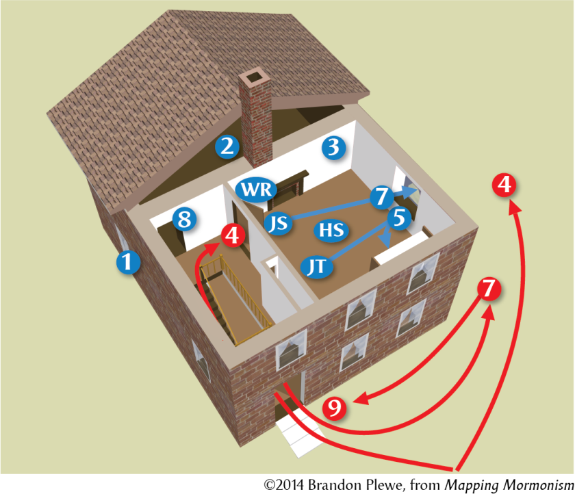
(2) June 26: The men are moved to the higher security "dungeon" for their protection.
(3) Due to the heat, they are allowed to sleep in the jailer's bedroom.
June 27, 4:30pm: a mob begins to gather in the street.
(4) 5:12pm: Several men burst into the jail, finding the guards missing and the door unlocked. The remainder stand outside shooting into the windows.
5:13pm: a shot through the door kills Hyrum.
(5) 5:14pm: Joseph attempts to hold the door shut, but it is forced partially open. John Taylor flees to the open window, but a shot in chest forces him back in, where he rolls under the bed.
(6) 5:15pm: Willard Richards pushes on the door, knocking down gun barrels with his cane, while Joseph runs for the window. Joseph is shot from the front and rear and falls out the window.
(7) The mob rushes outside to see Joseph.
(8) Richards drags the wounded Taylor into the dungeon and hides him under the mattress.
(9) Coming back in, mobsters see Richards in the dungeon doorway, but someone yells "The Mormons are coming" and the mob disperses, sparing his life. Kenneth W. Godfrey
Photo by Brandon Plewe, Mapping Mormonism p.63

The Camp of Israel crosses Iowa

The Camp of Israel crosses Iowa, February-June 1846
In October 1845, the Twelve announced plans to evacuate Nauvoo the next spring and seek a homeland in the West. About 17,000 Saints in the Nauvoo region had six months to get ready. Saints struggled to sell properties and construct or purchase wagons, teams, and provisions for the trek west. Plans called for at least 2,500 wagons evacuating the city.
By January 1846, rumors that the Twelve might be arrested or prevented from leaving caused them to leave early as a vanguard company with anyone ready to go. During February some 2,500 Saints gathered at the Sugar Creek encampment in Iowa (1), whom Young organized as a “Camp of Israel," departing March 1. Spring rain and mud slowed the way, forcing the Camp to take 3.5 months to cover the 300 miles to the Missouri River.
Initially they passed along existing roads. During extended stops (2), men worked for locals; for example, the brass band performed for pay in Keosauqua. The company hugged the Missouri border so they could trade with settlers to the south for livestock feed. Deciding not to cross northern Missouri (in which Mormons were still in danger) as originally planned, they turned northwest on April 12 (4) toward the Council Bluffs area, blazing a new trail. At this turning point, William Clayton wrote the hymn “Come, Come, Ye Saints” (5). Moving on, they created Garden Grove (6: April 24) and Mount Pisgah (7: May 26) as temporary settlements for those without means to continue, eventually reaching the Missouri River in mid-June (8). William G. Hartley
Photo by Mapping Mormonism p.74

The Vanguard Company Crosses the Plains

The 1847 Vanguard Pioneer Company
On April 7, 1847, the day after a general conference at Council Bluffs, Brigham Young began organizing a wagon train to head for the Salt Lake Basin. This vanguard company consisted of 143 men, 3 women, and 2 children and included a number of Apostles and other Church leaders; it was intended to be a scouting group to prepare for the families to follow. The train was held up for a week at the Elkhorn River to await the arrival of John Taylor, who was coming from England with some scientific instruments, including sextants, barometers, and a telescope, which allowed Orson Pratt to determine the latitude, longitude, and elevation of important landmarks along the way. The company also took a cannon with them to help guard against any Indian attacks. They were able to design and construct an odometer, which was attached to a wagon wheel to measure the distance they traveled each day. They noted the flora and fauna, soils, and rock formations along the way.
They stayed on the north side of the Platte and North Platte rivers until they reached Fort Laramie to avoid interaction with Oregon-bound travelers on the south side. Because they were the first wagon train to take this route, crews were sent ahead with tools to build the road through difficult terrain, knowing that many wagon trains would be following them. The rivers were running high with spring runoff, so they stopped to build ferry rafts and left crews behind to assist the companies that would follow that summer.
At Fort Laramie, they crossed to the south side of the river and followed the Oregon Trail across most of Wyoming. At Fort Bridger they followed the Hastings Cutoff to the southwest, used by the ill-fated Donner-Reed Party the year before. The first scouts entered the Salt Lake Valley on July 22 and were already plowing fields when Brigham Young arrived two days later, uttering the iconic words, “This is the right place; drive on.” Many of the men did not stay long, hurrying back east to prepare to bring their families. Wayne Wahlquist
Photo by Mapping Mormonism p.80-81

Entering the Salt Lake Valley

Pioneer Arrival in the Salt Lake Valley
Looking south over Meridian Peak across the Salt Lake Valley as it probably looked when the Mormon pioneers arrived in 1847. The valley was predominantly covered in tall prairie grass, with groves of willows, cottonwoods and box elder trees in the streambeds. The northwest part of the valley was less hospitable, with poor soil, alkaline deposits, salt marshes, and brackish ponds (such as Decker Lake, visible to the right). It was dotted with campsites utilized intermittently by Utes and Shoshones.
July 22: (1) George A. Smith and Orson Pratt climb Donner Hill and get the first view of the valley. (2) they lead the advance party down to a creek (now 1700 S 500 E) to camp.
July 23: (3) Men explore northward as far as the Hot Springs. (4) The camp moves to a better creek (City Creek, near 300 S State), where they begin digging irrigation ditches and planting potatoes
July 24: (5) Brigham Young and the sick party enter the valley and come to the new camp
July 25, Sunday: The pioneers rest and worship
July 26: (6) Young and eight others climb Ensign Peak to survey the valley and plan the city.
July 27: (7) Young and others. explore westward to the edge of Tooele Valley and swim in the Great Salt Lake. Meanwhile, the first of the combined Battalion detachment and Mississippi Company arrive from Pueblo.
July 28: (8) Orson Pratt leads a group up Traverse Mountain to see Utah Valley. (9) Young identifies the site of the future temple.
August: Orson Pratt calculates the coordinates and elevation of the temple site, then begins to survey the city lots. (10) A semipermanent fort is built (now Pioneer Park). Wayne Wahlquist
Photo by Brandon Plewe, Mapping Mormonism p.81

Weeks 46, 50: Plural Marriage and Extending the Priesthood (D&C 132, OD1, OD2)

Incidence of Plural Marriage, 1870

Incidence of Plural Marriage in 1870
The incidence of polygamy in 1870 shown on this map began as part of a project revisiting Twelve Mormon Homes, a book published by Elizabeth W. Kane, wife of Colonel Thomas L. Kane, a year after their journey from Salt Lake City to St. George in 1872–73. Another 45 towns were added to the 12 featured in Mrs. Kane’s book, many of them settlements mentioned by her in passing. Since the 1870 federal census did not identify each individual’s relationship to the head of household, it proved impossible to determine everyone’s marital status—making calculations subject to a ±3–5% margin of error.
That said, the map clearly shows that the influence of polygamy varied greatly, from 7% in Coalville to 68% in Bellevue (now Pintura). In tiny towns like the latter, one plural family could skew the figure significantly. Also, since most polygamists did not take a second wife for the first 5 to 15 years of their married life, towns with a high proportion of younger couples usually had fewer plural families. That may explain Hyde Park’s lower percentage, compared to Logan’s and Wellsville’s in 1870, even though Stake President Charles O. Card labeled it Cache Valley’s most polygamous place for its size in 1887.
Photo by Mapping Mormonism p.123

The Spread of the Church in Africa

Updated 2025!

The Spread of the Church in Africa
Prior to 1978, missionary work and membership in Africa was confined to a few former British colonies in the South with substantial Caucasian populations. Soon after the Revelation on Priesthood, new fields were opened there and in West Africa. Since then, dozens of countries have followed a similar pattern of 1) a branch in the capital city of expatriates and natives converted elsewhere, 2) arrival of proselytizing missionaries, 3) rapid growth in a few cities, leading to the organization of districts then stakes, then 4) widespread growth across the country and the building of temples. This process has slowed at times in some nations, often due to political instability and conflict, but others continue to grow rapidly, especially Nigeria (230,000 members in 2024) and the Democratic Republic of the Congo (115,000).
Photo by Brandon Plewe, Mapping Mormonism p.233 (updated January 2025)